TODAY'S WEATHER

LIVE WEATHER CHANNEL

FORECAST
TENNESSEE VALLEY WEATHER APPS
SUPPORT TENNESSEE VALLEY WEATHER
INTERACTIVE RADAR

CURRENT CONDITIONS
CURRENT WEATHER ALERTS


WATCH & WARNING MAPS UPDATE EVERY 15 MINUTES
TENNESSEE VALLEY WEATHER BLOG
Rain & thunder tonight. Low rain chances this weekend. Thunderstorms by Monday.
Warm weather looks like it’s here to stay. We have nothing by 70s and 80s for highs through next week! We do have rain and storms mixed in, as well as a few dry periods. As far as the rest […]
Read More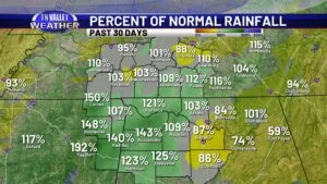
Drought conditions are gone locally, but just how exactly are we doing with rainfall?
It doesn’t take a meteorologist to know that it’s been a fairly wet spring so far here across the Tennessee Valley. I don’t think we’ve gone a full week-long stretch without at least small rain chances somewhere in the area […]
Read More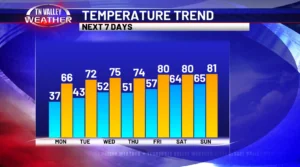
Tired of this cooldown? Don’t worry… Spring returns soon.
Well, we’ve made it to late April… but you can’t take that fact for granted – 70s and 80s being consistent are no guarantee. Today and yesterday have been a couple days of proof of that; in fact, today is […]
Read More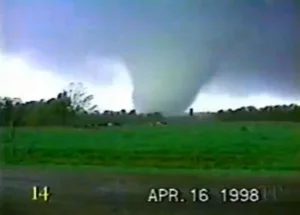
April 16th, 1998 Tornadoes – From Nashville to Lawrence County…
There are three certainties when it comes to life in Dixie: death, taxes, and tornadoes. In more ways than one, it’d even be right to suggest that tornadoes – indeed, weather as a whole – has shaped the history of […]
Read More